Death Valley National Park – Guide to Extremes, Attractions and Safety
Death Valley National Park represents the most extreme intersection of heat and elevation found anywhere in North America. Straddling the California-Nevada border, this 3.4-million-acre landscape holds the undisputed title for the hottest reliably recorded air temperature on Earth—134°F (56.7°C) registered at Furnace Creek Ranch in 1913—while simultaneously containing Badwater Basin, the continent’s lowest point at 282 feet below sea level.
The park’s stark beauty draws approximately 1.7 million visitors annually who navigate salt flats, sand dunes, and colorful canyons. Access requires a $35 vehicle entrance fee valid for seven days, though the America the Beautiful Pass provides alternative entry. While summer months deliver lethal temperatures exceeding 120°F, strategic timing between February and April or October and November reveals a surprisingly accessible wilderness.
Unlike temperate destinations such as the corridor connecting Montreal to Quebec City, this desert environment demands specialized preparation and respect for its climatic severity.
How Hot Does Death Valley National Park Get?
- Lowest Point: Badwater Basin sits 282 feet below sea level, the most depressed terrain in North America.
- Global Heat Record: Furnace Creek Ranch documented 134°F (56.7°C) on July 10, 1913, the highest reliably measured air temperature worldwide.
- Modern Extremes: Recent years confirm the trend, with 130°F recordings in 2020 and 2021 at the same monitoring location.
- Surface Temperatures: Ground temperatures routinely reach 200°F during peak summer months, capable of causing serious burns.
- Ecological Contrast: Despite heat, the park harbors the Desert Pupfish, the only native fish species adapted to Salt Creek’s harsh saline waters.
- Vertical Range: The topography spans from Badwater’s -282 feet to Telescope Peak at 11,049 feet.
- Climate Classification: Arid desert receiving less than two inches of annual precipitation on average.
| Attribute | Data |
|---|---|
| Established | 1933 (Monument), 1994 (National Park) |
| Elevation Range | -282 ft to 11,049 ft |
| UNESCO Status | International Biosphere Reserve |
| Primary Recording Site | Furnace Creek Ranch |
| Modern Heat Records | 130°F (2020, 2021) |
| Entrance Fee | $35 per vehicle (7 days) |
| Annual Precipitation | < 2 inches average |
| Indigenous Presence | Timbisha Shoshone |
Best Time to Visit Death Valley National Park
Optimal Seasonal Windows
Strategic timing determines whether visitors experience manageable exploration or life-threatening conditions. Late winter through spring (February to April) and fall months (October to November) provide mild daytime temperatures ranging from 60°F to 90°F, ideal for hiking and photography. These windows avoid the deadly summer period from May through September, when temperatures regularly exceed 110°F and occasionally surpass 120°F.
Entry Requirements and Fee Structure
Access costs remain standardized across entry points. Private vehicles pay $35 for a seven-day permit, motorcycles $30, and individual pedestrians or cyclists $20. The America the Beautiful Pass provides unlimited annual access. Rangers collect fees at entrance stations, with most attractions included in this base price. The Furnace Creek Visitor Center operates daily from 8 a.m. to 5 p.m., offering orientation films, topographic maps, and critical safety updates.
Dawn and dusk provide optimal lighting for capturing the park’s geological colors. Sunrise at Zabriskie Point illuminates badlands in golden-pink hues, while sunset at the Mesquite Flat Sand Dunes eliminates harsh midday shadows and reduces heat exposure risks.
What to See in Death Valley National Park
Badwater Basin and Elevation Extremes
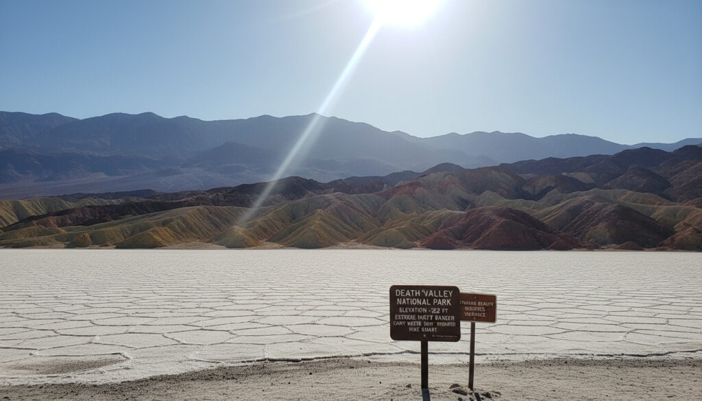
Badwater Basin marks North America’s lowest point at 282 feet (86 meters) below sea level, a vast hexagonal salt flat stretching across the valley floor. Visitors hike one or more miles across the slick, sticky surface, though sturdy shoes prove essential—salt residue corrodes vehicle interiors if not washed off immediately. Rare rainfall occasionally creates temporary Manly Lake, offering brief photographic opportunities before evaporation resumes.
Iconic Landscapes and Viewpoints
The Mesquite Flat Sand Dunes rise over 100 feet near Stovepipe Wells, providing accessible terrain for hiking, sandboarding, and astronomical observation. Zabriskie Point offers a short hike to badlands overlooks with an optional 2.5-mile Golden Canyon loop. Artist’s Drive, a nine-mile scenic route, winds past oxidized rock formations displaying purple, green, and pink strata. Dante’s View sits at 5,575 feet, delivering sweeping panoramas over Badwater Basin via a one-mile easy trail—though vehicles exceeding 25 feet are prohibited on the access road.
Additional formations include the jagged salt spikes of Devil’s Golf Course, the volcanic Ubehebe Crater, and the narrow, shaded walls of Mosaic Canyon. When selecting gear for these excursions, travelers should consider different preparation than choosing Best Carry On Luggage for urban travel, focusing instead on hydration capacity and sun protection.
Is Death Valley Dangerous and How to Visit Safely?
The Name’s Historical Origin
The ominous designation traces to 1849, when a group of pioneers lost their way during the California Gold Rush. One member perished in the basin before the survivors were rescued, allegedly declaring “Goodbye, Death Valley” upon their departure. Despite the macabre moniker, modern infrastructure and safety protocols prevent most tragedies—provided visitors respect environmental limits.
Heat and Hydration Protocols
Heat exhaustion and heat stroke represent the primary medical emergencies, with ground temperatures reaching 200°F in summer. Park authorities mandate drinking one gallon of water per person daily, supplemented with salty snacks to maintain electrolyte balance. Hiking should conclude before 10 a.m. during warm months, with afternoon hours reserved for air-conditioned vehicle transit.
Summer visits between May and September expose visitors to potentially lethal temperatures exceeding 120°F. Vehicle air-conditioning systems can fail under extreme loads, and breakdowns on remote roads create immediate survival emergencies. Pre-dawn starts and continuous hydration provide the only safe access during these months.
Navigation and Communication Challenges
Cellular service remains nonexistent across most of the 3.4-million-acre expanse, rendering GPS navigation and emergency calls unreliable. Flash floods pose sudden threats during rare rain events, transforming dry washes into torrents capable of sweeping vehicles away. Rattlesnakes inhabit rocky areas, requiring careful foot placement on uneven terrain. Low-clearance vehicles should avoid unpaved roads, which may feature soft sand or sharp rocks capable of puncturing tires.
Carry a minimum of three liters per person even for short hikes. The arid atmosphere wicks moisture from the body imperceptibly; by the time thirst manifests, dehydration has already compromised judgment and physical performance.
How Did Death Valley Become a Protected Wilderness?
- : The first non-Native settlers, a group of lost pioneers, enter the valley, giving the region its name after one fatality.
- : Commercial borax mining begins at Harmony Borax Works, utilizing 20-mule teams to haul ore across the desert.
- : The federal government designates the area as a National Monument under presidential proclamation.
- : Congress expands the protected status to National Park, increasing the preserved acreage significantly.
- : Furnace Creek Ranch records the world air temperature record of 134°F, a benchmark still recognized today.
- : Modern instrumentation at Furnace Creek records consecutive 130°F temperatures, confirming continued extreme conditions.
What Conditions Are Certain and What Remains Variable?
| Established Facts (NPS Verified) | Variable Conditions (Check Current Status) |
|---|---|
| Badwater Basin elevation: 282 ft below sea level | Daily temperature fluctuations (60°F+ swings possible) |
| Furnace Creek record: 134°F (1913) | Road closure status (winter flash floods, summer heat protocols) |
| Entrance fees: $35 vehicle, $30 motorcycle, $20 individual | Temporary lake formation at Badwater (rain-dependent) |
| Telescope Peak elevation: 11,049 ft | Wildflower bloom intensity (spring variability) |
| Timbisha Shoshone indigenous presence (continuous) | Flash flood timing and severity |
| Desert Pupfish habitat: Salt Creek only | Cellular service availability (provider-dependent dead zones) |
What Geological and Cultural Context Defines the Park?
The Timbisha Shoshone people have inhabited this basin for millennia, developing sophisticated survival strategies for the arid environment. European-American exploitation began in the 1880s with borax extraction at Harmony Borax Works, where twenty-mule teams hauled 30-ton loads across 165 miles to railheads. These operations ceased when more accessible deposits were found elsewhere, leaving behind rusted machinery now preserved as historical artifacts.
Geologically, the valley represents a graben—a sunken block between parallel mountain ranges—where ancient Lake Manly once covered the basin floor. Evaporation left concentrated salt deposits forming the present-day Badwater Basin flats. Telescope Peak rises to 11,049 feet within the Panamint Range, creating a vertical relief exceeding two miles within the park boundaries. This extreme topography generates microclimates supporting isolated populations of the Desert Pupfish, which survive in Salt Creek’s saline waters where no other native fish can persist.
What Do Official Sources Say About Visiting?
“Drink plenty of water: Drink at least one gallon (4 liters) of water per day to replace loss from sweat, more if you are active. Carry and drink water while hiking. Being thirsty is not a good indicator of your body’s water needs.”
— National Park Service, Death Valley Visitor Safety Guidelines
“Badwater Basin is the lowest point in North America at 282 feet below sea level. The salt flats here cover nearly 200 square miles and are composed mostly of sodium chloride (table salt), along with calcite, gypsum, and borax.”
— National Park Service, Geological Survey Data
What Should Visitors Remember for 2025?
Death Valley National Park rewards those who arrive prepared for its contradictions—lethal heat alongside delicate wildflowers, scorched salt flats beneath snow-capped peaks. Successful 2025 visits require advance reservations at Furnace Creek Ranch or Sunset Campground, vehicles with reliable air conditioning, and flexible itineraries accommodating sudden weather changes. Whether exploring for 24 hours or two days, the park delivers geological drama unmatched elsewhere on the continent—provided visitors respect the environment that earned its name.
Common Questions About Death Valley
How many days are needed to see Death Valley National Park?
A single day covers Badwater Basin, Zabriskie Point sunrise, and Mesquite Flat Sand Dunes. Two days allow for additional exploration of the west entrance, Darwin Falls, and Artist’s Drive.
Is Death Valley worth visiting despite the extreme heat?
Yes. The park offers North America’s lowest point, world-record temperatures, and unique geology including moving rocks and colorful canyons inaccessible elsewhere. Proper timing avoids dangerous summer conditions.
Can you drive through Death Valley National Park?
Yes. California State Route 190 provides paved access across the park, connecting Furnace Creek and Stovepipe Wells. Most major attractions feature paved access roads, though some viewpoints restrict vehicles over 25 feet.
What is the entrance fee for Death Valley National Park?
Private vehicles pay $35 for seven days, motorcycles $30, and individuals entering by foot or bicycle $20. The America the Beautiful Pass grants unlimited annual access to all federal fee areas.
Is the park dangerous during summer months?
Yes. Temperatures exceeding 120°F create lethal conditions for unprepared visitors. Heat stroke, dehydration, and vehicle breakdowns present serious risks. Rangers recommend against hiking after 10 a.m. during summer.
Why is it called Death Valley?
The name originated in 1849 when pioneers became lost crossing the basin. One person died before the group found escape routes, allegedly cursing the valley with their final words.
What is the lowest point in North America?
Badwater Basin sits 282 feet (86 meters) below sea level, marked by a permanent sign and a vast salt flat extending across the valley floor.
More related posts
 Paul Newman: His Life, Death, Family, and Philanthropic Legacy
 Manny Machado: Ethnicity, Contract, Stats, and Career Facts
 Dov Charney: American Apparel Founder, Net Worth, Comeback 2026
 We tern Auto Group Review : What Cu tomer Say in 2025
 The Better Sister Cast: Jessica Biel, Elizabeth Banks
 Cult of the Lamb: Parent’s Guide to Content, Rating & LGBTQ
 Une Chance Qu’on S’a: Meaning, Lyrics, Writers, Covers
 Who Is Winning the Blue Jays Game? Game 7 Score & Odds